Backroad Mapbooks
Backroad Maps GPS TOPO for Garmin Handhelds - SD Card - Western Canada
Backroad Maps GPS TOPO for Garmin Handhelds - SD Card - Western Canada
Couldn't load pickup availability
Western Canada
Be Your Own Guide With Our Version 2020 GPS Maps for Western Canada!
From the wild ocean coast, towering mountains and hidden valleys of BC to the majestic Rockies, rolling foothills and sweeping prairies of Alberta, the wide-open sky and fertile grasslands of Saskatchewan and the untamed wilderness and 100,000 lakes of Manitoba, Western Canada is a land of stark contrast and incredible adventure opportunity. Whether you are hiking, biking, ATVing, snowmobiling, horseback riding, snowshoeing or cross-country skiing, let our Version 2019 GPS Maps guide you on an adventure of a lifetime as you explore Western Canada.
Industry Leading Topographic Contours and Shading
These Garmin-licensed GPS Maps feature the height of cartographic sophistication, giving you the most detailed, easy-to-use and comprehensive maps available for Western Canada.
What’s New in Version 2020:
- BRMB GPS Maps are compatible with the new Garmin 66i unit with inReach technology
- Added new Saskatchewan Crown Land and Grazing Reserves
- Enhanced our Routable Roads with close to 25,000 km of improvements to our Forest Service and backroad network, including adding road names and upgrading non-routable roads to routable
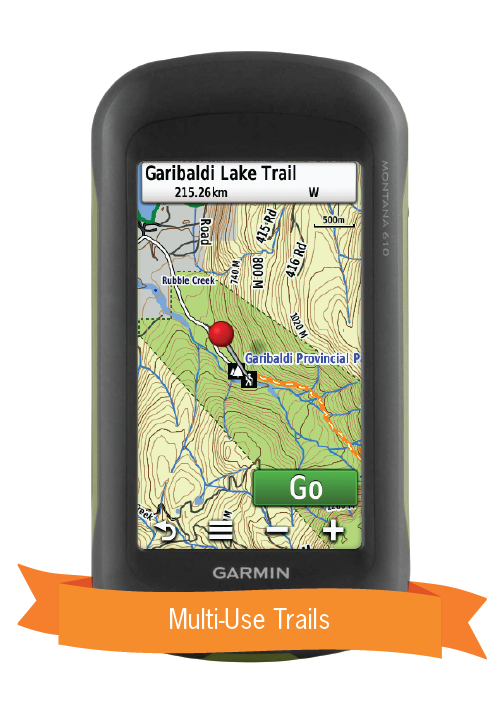
- Added close to 2,200 km of new Multi-Use Trails including the Trans Canada Trail with 700+ new trailheads
- Added close to 7,350 km of new motorized trails for ATV’s and Snowmobiles including close to 200 new trailheads and staging areas
- Added 1,400+ km of new Paddling Routes including 260+ new access and portage locations
- Added 220+ new Provincial, National and Urban Parks including close to 570 new Campsites, Backcountry Campsites, Day Use/Picnic Areas and Huts/Shelters
- Added close to 2,800 new First Nations Reservations
- Added close to 125 new Public Access locations
- Added 105 new Winter Recreation adventures for cross-country skiing and snowshoeing
- Added close to 100 new Backroad Attractions including historical sites and points of interest
- Added close to 90 new Wildlife Viewing points of interest including Scenic Areas and Fire Towers
- Added 70+ new Waterfalls
- Added close to 65 new Fishing Lakes, Rivers and Streams including 15+ new Boat Launches and Marinas
- Added thousands of mile markers along Railway Corridors
- Enhanced the Snowmobile Route cartography for improved display
So Much More Than Just Maps!
Backroad Mapbooks’ industry-leading topographic maps are trusted by recreationists and industry workers alike, and are even the maps of choice for search and rescue organizations. Also included in the GPS Maps are detailed written descriptions of hunting areas, fishing lakes and rivers, national and provincial parks, wildlife viewing areas, multi-use trails and more.
Western Canada GPS Map Features:
- Close to 425 Wildlife Management Units in BC and AB, over 80 Wildlife Management Zones in SK and over 60 Game Hunting Areas in MB for hunters
- Over 1,550,000 km of our backroads network combined into one map, including over 870,000 km of routable roads
- Fishing Lakes and Rivers with 6,500+ locations with descriptions and fish species
- Close to 1,600 Boat Launch locations
- Over 7,500 Trails with front country and backcountry locations and descriptions, or 68,000+ km of trails in total
- Snowmobile Trails with close to 980 trailheads/staging areas and descriptions, or 91,000+ km of trails in total
- ATV Trails with over 800 trailheads/staging areas and descriptions, or 77,000+ km of trails in total
- Parks with over 45300 National, Provincial, Regional Parks and Conservation Areas with descriptions
- Close to 2,000 Backcountry campsites
- Over 2,300 Campground and Picnic locations
- Paddling with 4,300+ paddling route access points descriptions and portage locations, or 52,000+ km of routes in total
- 800+ Winter Recreation Sites and Downhill Ski Areas
- 900+ Wildlife Viewing locations and descriptions
- 9,600+ City, Town and Community locations
- 100,000+ searchable land and water geographic features
- 750 Backcountry Huts and Cabins
- Lake Bathymetry depth contour for 2,250+ fishing lakes, rivers, and streams.
- Garmin-licensed & compatible with Garmin GPS™, Basecamp™, MapSource™ and RoadTrip™.
- Includes all standard Garmin features such as Find tool, city navigation and more.
- Preloaded 1:20,000 / 1:50,000 base scale seamless topographic maps.
- Provides 3D views and the highest level of map detail available on select Garmin GPS units and Basecamp™.
- Searchable BRMB descriptions and activity information for fishing, paddling, parks, trails and more.
- Includes Oil and Gas LSD Grid Locations, Compressor Stations, Gas Plants, Wellsites and other Resource Facilities
- Showcases private/leased land areas in BC.
- Features Address and Township & Range searching to aid navigation in Alberta, Manitoba and Saskatchewan.
- Industry leading cartographic contours and shaded relief for all of British Columbia, Alberta, Saskatchewan and Manitoba.
Share