Backroad Mapbooks
Backroad Maps GPS TOPO for Garmin Handhelds - SD Card - Northern CAD (YK/NU/NWT)
Backroad Maps GPS TOPO for Garmin Handhelds - SD Card - Northern CAD (YK/NU/NWT)
Couldn't load pickup availability
Canada’s Final Frontier
Home to vast expanses of untouched wilderness, Canada’s north is legendary among outdoor explorers for its beauty and magnitude. Pristine rivers run for thousands of kilometres through towering mountain ranges, deep canyons and barren tundra. Polar bears, muskoxen and caribou roam the land while falcons and eagles fly overhead. In the summer, the midnight sun means your adventures can carry you through the night, while the winter offers incredible views of the aurora borealis. With just a couple of major cities found in the region, this is truly a place where nature dominates, with a scattering of small Inuit communities providing the primary access to much of this wild land.
Northern Canada GPS Maps at a Glance
- Combining day-to-day navigation with enhanced outdoor recreation information, this product combines all of the northern territories into one title, covering all of Yukon, the Northwest Territories and Nunavut.
- Over 73,000 land and water geographic features help you navigate the landscape with the knowledge of a local.
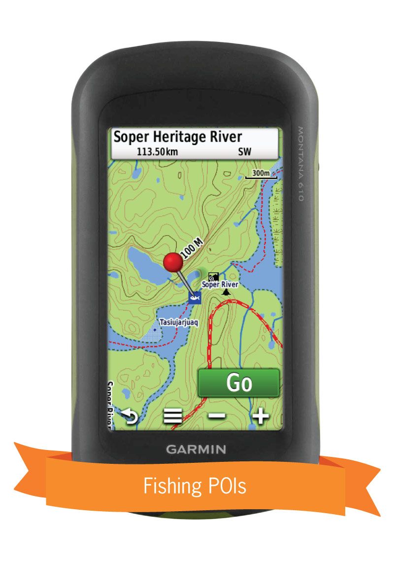
- Lake bathymetry (depth contour) for popular fishing lakes in the Yukon.
- Over 25,500 km of our backroads network combined into one map, including over 19,200 km of routable roads.
- Industry leading contours and topographic relief
- Over 14,200 km of paddling routes for canoeing, kayaking and rafting.
- Marked Game Management Areas (GMAs), Wildlife Management Units (WMUs) and Wildlife Management Zones (WMZs) for hunters.
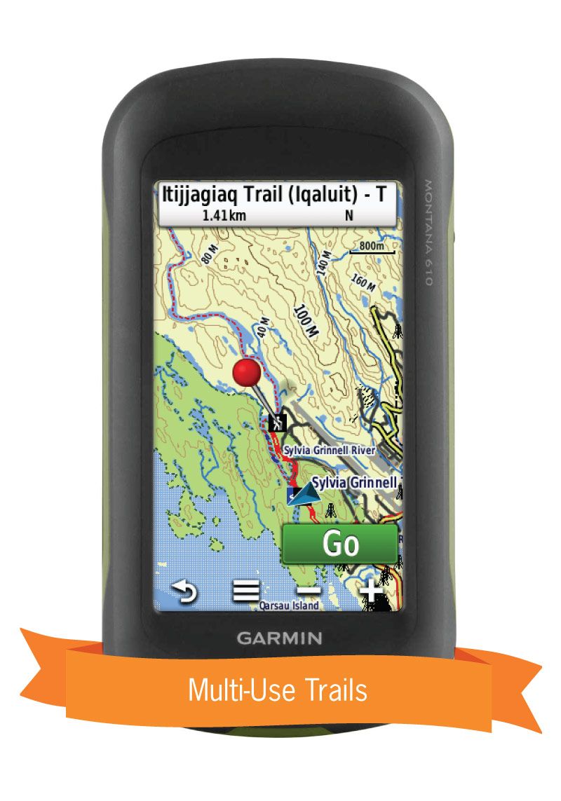
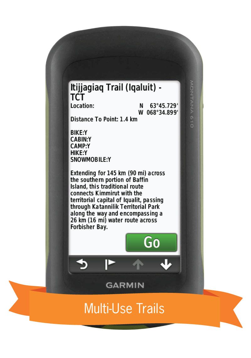
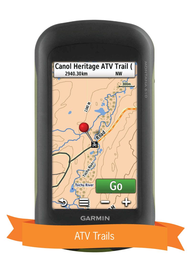
- Over 3,200 km of snowmobile trails, plus over 2,800 km of ATV trails and over 2,500 km of multi-use trails for hikers, mountain bikers, cross-country skiers and snowshoers.
- Hundreds of fishing lakes, rivers and streams and hundreds of national, territorial and municipal parks.
- Enhanced snowmobile route cartography for improved display.
- Thousands of new mile markers along railway corridors.
So Much More Than Just Maps!
Backroad Mapbooks’ industry-leading, Garmin-licensed Northern Canada GPS Maps are the most detailed, comprehensive and up-to-date GPS maps available on the market. Our GPS Maps are the maps of choice for recreation, industry and even search-and-rescue, with countless geographic and activity-based Points of Interest. Updated regularly, these GPS Maps are Garmin licensed for compatibility with Garmin GPS and Basecamp. Available in Micro SD format, these Northern Canada GPS Maps are easy to install and use and bring all the detail you have come to expect from a Backroad Mapbooks product directly to your GPS device or computer. Keep your adventure rolling with the latest topographic data, routable roads, Wildlife Management Units and Game Management Areas, multi-use trails, ice roads, campgrounds, national and territorial parks and much more. With these Northern Canada GPS Maps in hand, your options for adventure are limitless.
Northern Canada GPS Map Features
- Garmin licensed and compatible with Garmin GPSTM, BasecampTM, MapSourceTM and RoadTripTM.
- Includes all standard Garmin features such as Find tool, City Navigation and more
- Preloaded seamless topographic maps with the highest level of map detail available on select Garmin GPSTM units and BasecampTM.
- Compatible with the latest Garmin 66i unit and inReach technology.
- The most complete paddling route and snowmobile trail coverage available for Northern Canada.
- Extensive routable road network plus thousands of kilometres of multi-use trails for hikers, mountain bikers, cross-country skiers and snowboarders
- Includes National, Territorial and Regional Parks and Campgrounds.
- Features smart background and searchable Game Management Areas (GMAs), Wildlife Management Units (WMUs) and Wildlife Management Zones (WMZs) for hunters.
- Searchable BRMB descriptions and activity information for fishing, paddling, parks, trails and more.
- Extras like lake and stream fishing with boat launches, paddling access points and more.
- Thousands of searchable geographic land and water features.
- And much more!
Northern Canada Road and Trail Highlights
- Over 25,500 km of roads, including over 19,000 km of routable roads.
- Over 14,200 km of paddling routes for canoeing, kayaking and rafting.
- Over 3,200 km of snowmobile trails, plus over 2,800 km of ATV trails and over 2,500 km of multi-use trails for hikers, mountain bikers, cross-country skiers and snowshoers.
Share